GPS Map Camera Android
Download for Android Download for IOS- Category:Photography
- Rating: 4.9
- Language:English
- Updated:2025-12-22
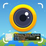
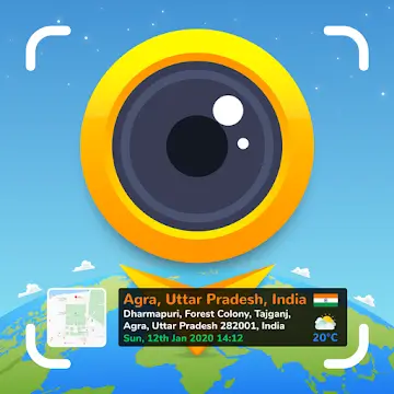
Screenshots


Introduction
GPS Map Camera is a fun photo editing app that allows users to add location, time, latitude and longitude, weather, and other data to photos. Users can then share these photos with friends or on other social media platforms, allowing others to like and comment on their travel moments. GPS Map Camera also offers a variety of GPS stamps and customizable map templates to help users add more precise location markers. Don't miss out on GPS Map Camera if you want to make your photos more interesting!
Features:
GPS Tagging: The core feature of GPS Map Camera is its ability to embed GPS data into photos. This includes latitude, longitude, altitude, and address information. Users can also add custom tags and notes to further describe the location and context of the image.
Customizable Watermarks: The app allows users to add customizable watermarks to their photos. These watermarks can include the date, time, GPS coordinates, and additional text. This feature is particularly useful for professionals who need to present documented evidence with precise location and time details.
Offline Mode: GPS Map Camera offers an offline mode, allowing users to capture and store GPS-tagged photos even when they are out of network coverage. The app will automatically update the location data once an internet connection is re-established.
Batch Processing: For users who need to process multiple images simultaneously, the batch processing feature is invaluable. This function enables the application of GPS tags and watermarks to multiple photos in one go, saving time and effort.
Map Integration: The app is integrated with various map services such as Google Maps and OpenStreetMap. This allows users to view the exact location of their photos on a map, making it easier to organize and share location-based information.
Cloud Storage Integration: GPS Map Camera supports integration with cloud storage services like Google Drive and Dropbox. Users can automatically back up their photos to the cloud, ensuring their data is safe and accessible from any device.

Highlights:
Geotagging: At the heart of GPS Map Camera are its robust geotagging capabilities. This feature automatically embeds precise location details—latitude, longitude, and address—into each photo's metadata. For travelers, this means each picture comes with a digital memory of where it was taken, turning your photo gallery into a detailed travel diary.
Weather Information: Understanding the environment during the moment captured is made easy with the weather information feature. Each photo can display current conditions like temperature, humidity, and wind speed. This addition is perfect for outdoor enthusiasts and professionals who need to record weather conditions for their activities.
Date and Time Stamps: With date and time stamps, users can easily organize their photos chronologically. This Main Features helps in documenting events and creating timelines, which is invaluable for both personal archives and professional portfolios.
Customizable Templates: The app offers a variety of templates that users can customize. Whether you’re a real estate agent needing to showcase property photos with detailed captions or a tourist wanting to remember specific details about a location, these templates make it easy to tailor your photos to fit your needs.
Social Sharing: Interactive Elements like social sharing are seamlessly integrated, allowing users to post their geotagged photos directly to social media platforms. This feature not only makes sharing easier but also invites commentary and interaction from friends and followers.

Useful Tips:
Choose the Right Map Type: Use the Hybrid Map for maximum accuracy it combines satellite imagery with street names, perfect for audits and progress reports. The Satellite View works best for field surveys and environmental documentation.
Show Both Address and GPS Coordinates: Turn on Address + Coordinates mode. The address adds readability for clients, while coordinates act as irrefutable proof for verifiers and auditors.
Select a Readable Font Style and Color: For outdoor photos, use bold white or yellow fonts for contrast. For bright indoor photos, go with dark gray or navy text. Keep font size between 14–18 px so details are easily readable on mobile screens.
Ideal Map Placement: Place the map overlay at the bottom-right corner. It looks cleaner and avoids covering the main focus of your image. This layout performs well in Google Image SEO, where clarity matters for ranking.
Accurate Date & Time Format: Use the format DD-MM-YYYY, HH:MM AM/PM—this format matches India’s audit and reporting standards. Enabling “time zone” helps when submitting reports across regions.

User Reviews:
The app is stellar, beyond my expectations. I need this app for working as an OSP fieldsurveyor and it does exactly what I need. However, the only thing I can say that bothersme, is that the orientation lock holds no value on the app. I tend to walk from one utilitypole to another, with my phone attached via lanyard, and I take photos of the utility polesper my contract. The photos will end up being upside down or sideways. This is my onlypeeve about the software, everything else works as I personally need it to. Thank y'all forhearing me and for providing this tool.
I originally sought an app that could be used as backup"proof" for my grocery deliveryjob. You can do everything right & still have customers file fraudulent claims that they'reorders were never delivered, just to get a full refund for groceries that they ordered "andreceived". With this app, I can complete the delivery & sit there until the customer openstheir door and starts grabbing their groceries and then I snap"photo proof", completewith GPS location, time/date stamp, and residential address(if available). Delivery driverscan lose their jobs because of customer fraud. This app helps level the playing field.
Like this app. It works pretty good. There are a couple things I'd like to see changedthough. First I think the stamp(overlay) should be closer to the bottom of the image.Possibly be able to specify the position. Second I'd like a little bit more flexibility in thenotes and make up of the overlay. Something like you get x lines so if you only have saythe date/time and the position like I use, you could allow for extra line ofnotes/description. Other than that I think it works great.
Final Verdict:
GPS Map Camera is a mobile utility tool designed for Android devices that helps users geotag their photos with real-time location data. Unlike a regular camera app, this one adds detailed geographic and environmental information to each photo the moment it’s taken. This includes latitude, longitude, address, weather, compass direction, altitude, and even magnetic field details, all stamped directly onto your pictures.The app serves one main purpose: to visually document the where and when of every photo. Whether you’re documenting fieldwork, construction sites, travel spots, or just want to remember exactly where a picture was taken, this app automatically embeds all that context into the image. It’s especially helpful for professionals who rely on verified data, like real estate agents, engineers, and surveyors.
More Information
- Size:59.5MB
- Version:1.9.2
- Requirements:Android
- Votes:327
Related Versions


Related topics
-
Welcome to our image editing apps! Perfect for beginners and pros alike, they make photo enhancement easy. Use PicsArt to crop, adjust colors, and apply filters. Remove backgrounds instantly with Remove.bg. Get creative with layers and advanced tools on Adobe Photoshop Express. Start transforming your images today!
-
![MintAI]()
MintAI
-
![FoodieFoodie]()
FoodieFoodie
-
![B612]()
B612
-
![Butter Camera]()
Butter Camera
-
![YouCam Makeup]()
YouCam Makeup
-
![PhotoTune]()
PhotoTune
-
![Luminar]()
Luminar
-
![Magic Eraser]()
Magic Eraser
-
-
Visuals serve as a primary gateway for players to engage with games, where distinctive art direction immediately captures attention and creates lasting impressions. An unconventional aesthetic not only stands out in crowded markets but also enhances immersion and emotional connection. When executed with creativity and polish, striking visuals elevate gameplay into a memorable artistic experience. That's why titles with truly exceptional art styles deserve recognition - they offer both visual delight and meaningful interactive expression that resonates with players long after the session ends.
-
![MintAI]()
MintAI
-
![FoodieFoodie]()
FoodieFoodie
-
![B612]()
B612
-
![Butter Camera]()
Butter Camera
-
![GPS Map Stamp Camera]()
GPS Map Stamp Camera
-
![YouCam Makeup]()
YouCam Makeup
-
![Luminar]()
Luminar
-
![ProCam X]()
ProCam X
-
-
Enhance your photos effortlessly with the best free photo editing apps for Android! Whether you want to apply stunning filters, adjust brightness and contrast, remove blemishes, or create professional-quality edits, these apps offer powerful tools at your fingertips. From simple one-tap enhancements to advanced editing features like background removal and AI-powered effects, you can transform your images with ease. Explore a wide range of user-friendly and feature-rich apps, all available for free download. Start editing and make your photos stand out today!
-
![New Profile Pic]()
New Profile Pic
-
![MotionPortrait]()
MotionPortrait
-
![FotoPlay]()
FotoPlay
-
![Hypic Photo Editor]()
Hypic Photo Editor
-
![SCRL: Photo Collage Maker]()
SCRL: Photo Collage Maker
-
![Snapseed]()
Snapseed
-
![Polarr]()
Polarr
-
![Square InstaPic]()
Square InstaPic
-


Latest Updated


Popular Apps


Popular News
-
![Tomie Wants to Get Married Full Walkthrough, All Choices and Ending Guide]()
Tomie Wants to Get Married Full Walkthrough, All Choices and Ending Guide
2026-05-22
-
![Karryn’s Prison Gameplay Walkthrough & Strategy Guide]()
Karryn’s Prison Gameplay Walkthrough & Strategy Guide
2025-10-28
-
![Life in Santa County Game Guide & Complete Walkthrough]()
Life in Santa County Game Guide & Complete Walkthrough
2025-10-28
-
![Dreams of Desire Complete Walkthrough and Game Guide]()
Dreams of Desire Complete Walkthrough and Game Guide
2025-10-28
-
![Era Hunter Gameplay Guide & Full Walkthrough]()
Era Hunter Gameplay Guide & Full Walkthrough
2025-10-28
More+