
AlpineQuest
Download for Android This app is available for Android only.- Category:Nav
- Rating: 4.0
- Language:English
- Updated:2025-02-26
Screenshots
Introduction
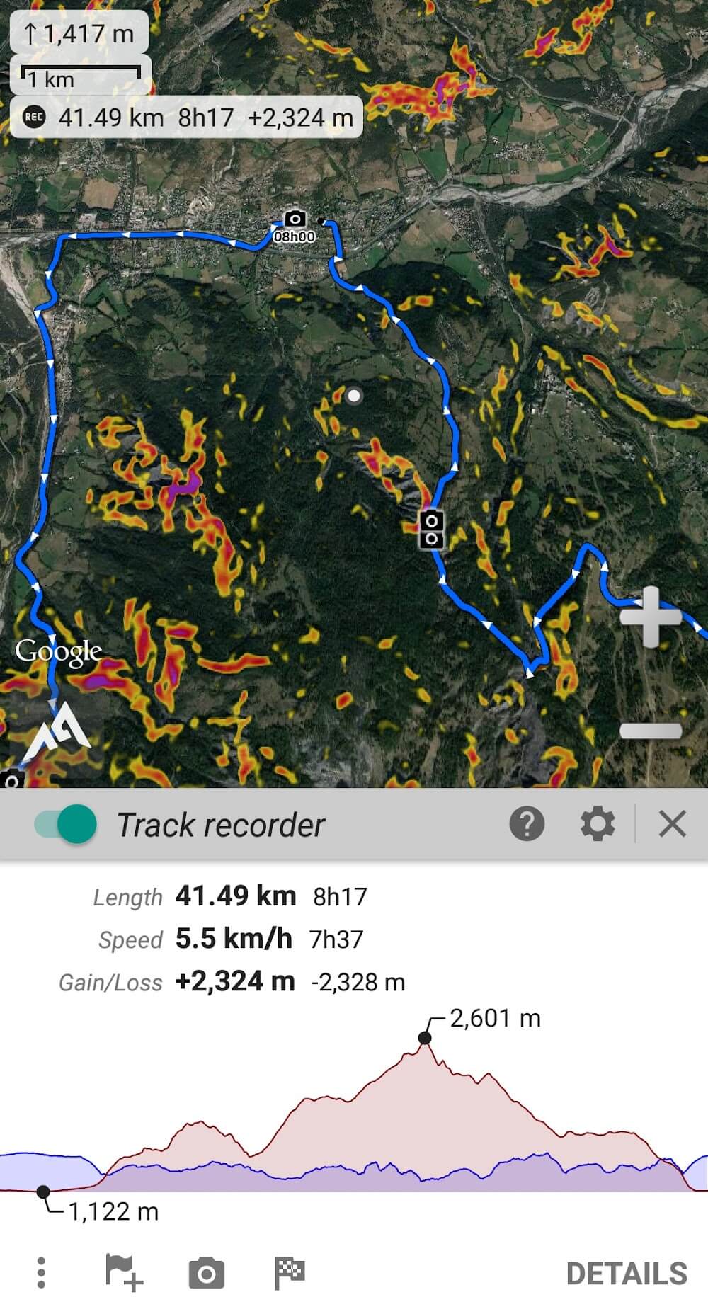
AlpineQuest GPS is a GPS application with topographic maps designed thinking of the needs of sportsmen who practice outdoor sports like climbing, hiking, hunting, sailing and other similar activities.The application comes with an integrated compass and will allow you not only to see your position on the map but also to know at all times where you are exactly, showing coordinates with information on altitude and latitude. You will also be able to export this data to other applications or share them through the Internet.
Features:
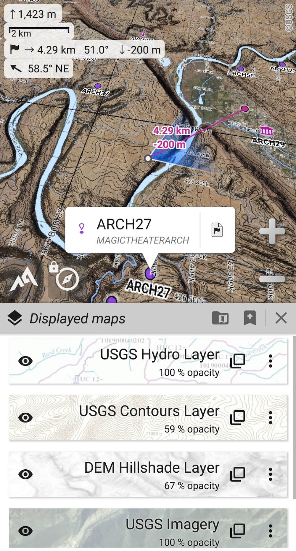
AlpineQuest GPS Hiking comes packed with a multitude of features to help you navigate the great outdoors. The app allows you to display maps from various sources, including OpenStreetMap, Microsoft Maps, and many others. You can also save these maps on your device for offline use, which is particularly useful when you're venturing into areas with no data connection.
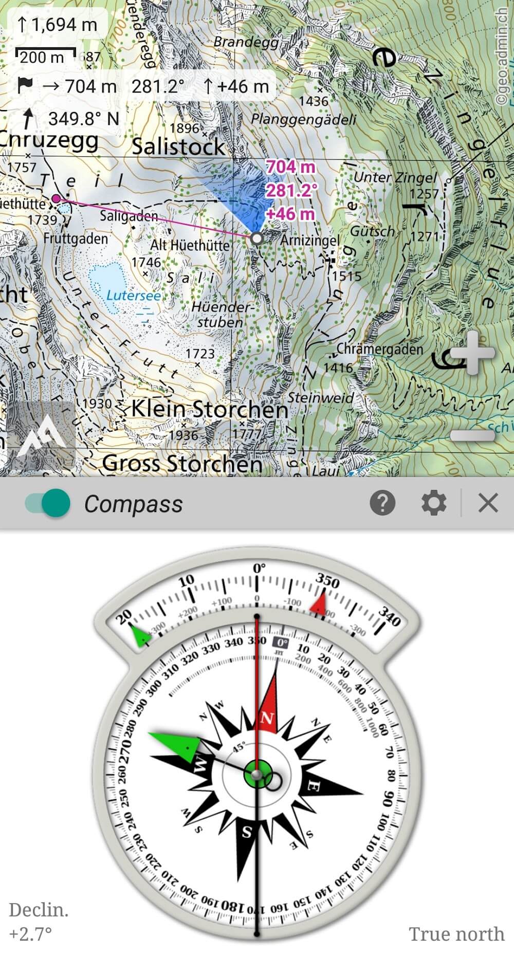
GPS and Compass: The app provides real-time location tracking using your device's GPS. It also includes a built-in compass and an altitude graph, allowing you to monitor your progress and stay on track.
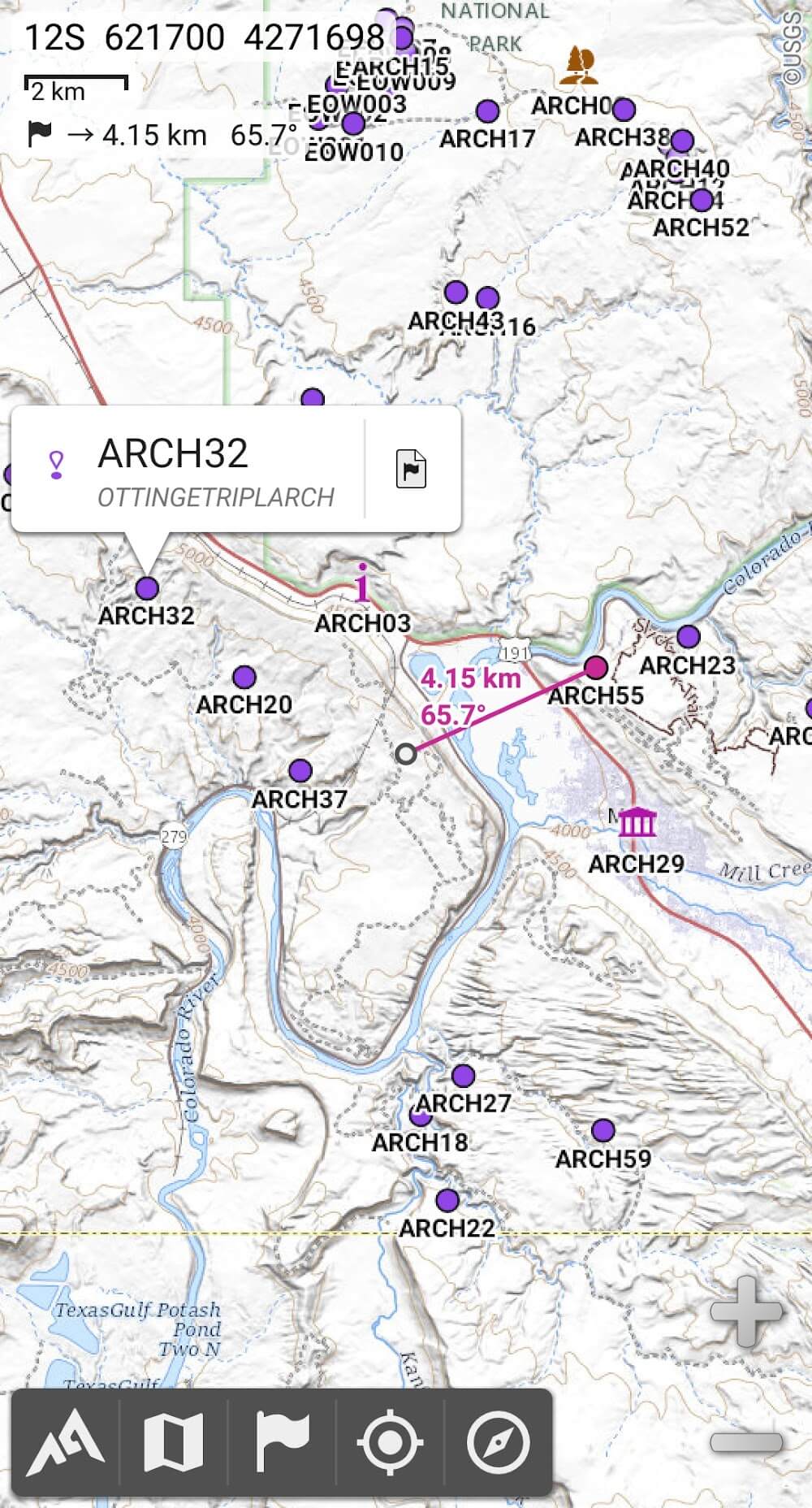
Waypoints and Tracks: With AlpineQuest, you can create and manage waypoints and tracks. This feature lets you mark important locations or routes on your map, which you can then share with others.
Distance and Bearing Tool: This nifty tool allows you to calculate the distance and bearing between two points on the map. It's particularly useful when planning your route or tracking your progress.
NAVIGATION:
This application will help you navigate, it will take you to the exact location you want. If you are climbing a mountain in a forest, the application will signal and clearly show you each location to help you conquer your goal.
Turn-by-turn: You will be given detailed, specific instructions and very clear, easy-to-understand voice prompts, helping users figure out where they are.
Terrain shading: On the road you go through, you will clearly know the change in elevation.
Waypoint guidance: With extremely enthusiastic and detailed guidance, you will know what lies ahead on your path and so you will more easily adapt to it.
Navigation options: You have the right to choose navigation depending on the medium you are using. Maybe you’re riding a bike or walking on any terrain.
Elevation data: Make a clear travel plan for yourself to have the most smooth journey.
Highlights:
Saving and sharing unlimited placemarks with friends is a great feature.
By adding this functionality to a digital platform, users can store an unlimited number of placemarks. This helps organise and access location marks and improves user experience. Saving placemarks lets people note important places. A fantastic tool for personal navigation and data analysis lets users track their progress and view advanced statistical insights and appealing interactive visualisations. This new system lets users rigorously follow their trip to understand their movements and activities. By using cutting-edge technology, this extraordinary instrument changes how people see and one will no longer doubt their potential.
Operate in different regions
alpinequest's capacity to operate in areas without cell coverage, such as distant mountainous regions or foreign territories, makes it a useful tool for outdoor exploration. Privacy and data security are top priorities in the digital age. Users are increasingly suspicious of internet threats such ads, data sharing, monetization, analytics, and third-party libraries. These problems must be addressed and a platform that prioritises user privacy and security provided. First and foremost, online ads are everywhere. They may provide cash for numerous sites, but they often disrupt users' browsing experiences and violate their privacy. Users can enjoy a distraction-free internet experience by removing ads.
Now is the time to try the free lite version.
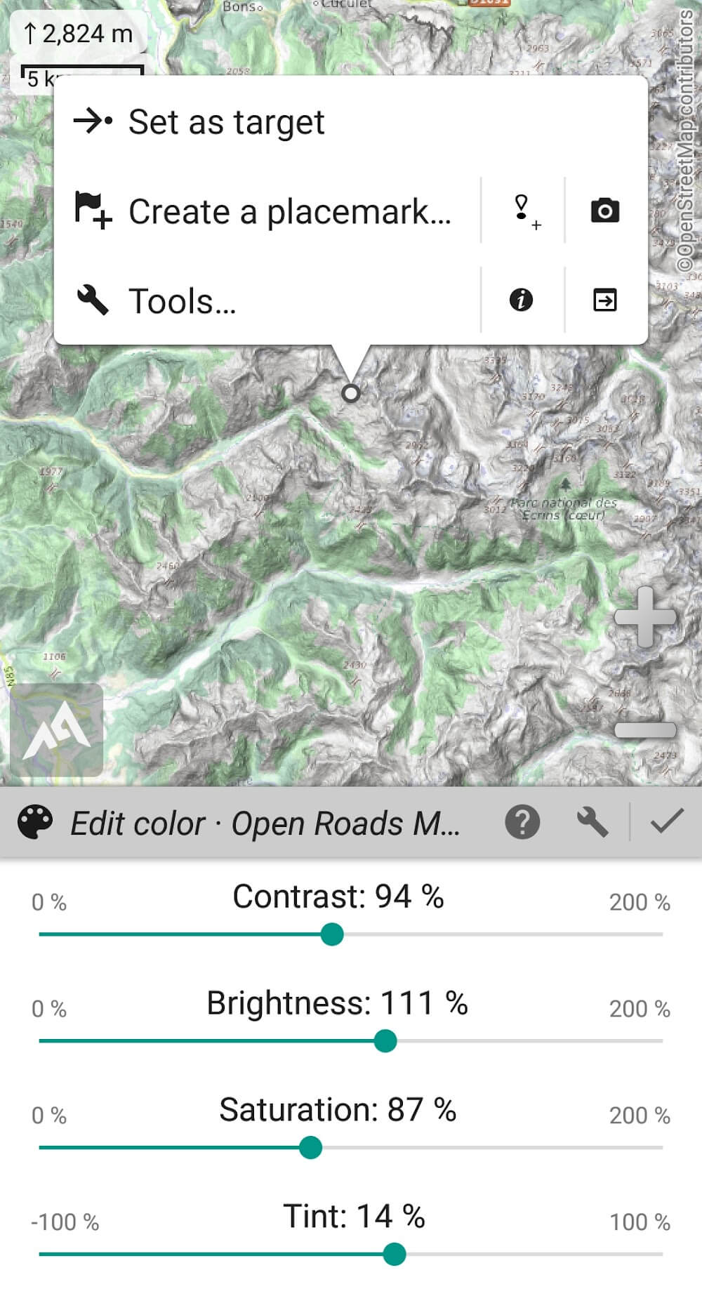
Highlighting the most important traits is crucial when examining critical traits. These traits are crucial to defining the subject matter. Maps are crucial to cartography. These visual representations of geographical information aid navigation, exploration, and understanding. Built-in road, topographic, and satellite maps and automated local storage are notable features. These maps give users a complete picture of their surroundings, making navigation easy. Online layers like route names, hillshade, and contours increase these maps' functionality, giving users more detailed information and a better understanding of their surroundings.
Frequently Asked Questions (FAQs):
Q1. What makes AlpineQuest better than other navigation apps?
A1. AlpineQuest's ability to store maps offline, its support for various map formats, and its real-time GPS and compass functionality make it a powerful and reliable tool for outdoor navigation.
Q2. Can I use AlpineQuest in areas with no cell coverage?
A2. AlpineQuest is designed to work seamlessly in areas with no cell coverage, making it ideal for remote wilderness exploration.
Q3. Is my data safe with AlpineQuest?
A3. AlpineQuest is committed to user privacy and does not display ads, share data for monetization, use analytics, or incorporate third-party libraries.
Q4. Can I share my location with friends while using AlpineQuest?
A4. You can share placemarks and your current location with friends using AlpineQuest.
Conclusion:
In summary, AlpineQuest is a robust and reliable app for outdoor navigation. Its comprehensive features, intuitive interface, and reliable performance make it a valuable tool for anyone venturing into the great outdoors. The app does require a bit of a learning curve for beginners, and some premium features require in-app purchases, but these are minor drawbacks in an otherwise excellent application.
More Information
- Size:8MB
- Version:2.3.9
- Requirements:Android
- Votes:384
Related topics
-
When you are traveling or experiencing a new place or activity, no one wants to stare at their phone or tablet the whole time. However, you want the memories of your trips and travel to last forever, and you want to share those memories with friends and loved ones back home. The best travel logs combine both worlds with stunning features and interfaces to document your memories, photos and videos of the places that you visit and simple, easy-to-use design. These some trip logging apps let you easily capture the memories, so you can get back to enjoying it in the moment.
-
![Namma Yatri]()
Namma Yatri
-
![HERE WeGo]()
HERE WeGo
-
![GPS Emulator]()
GPS Emulator
-
![Google Maps]()
Google Maps
-
![National Train Enquiry System]()
National Train Enquiry System
-
![Porter Driver Partner App]()
Porter Driver Partner App
-
![Where is my Train]()
Where is my Train
-
![Flightradar24 Flight Tracker]()
Flightradar24 Flight Tracker
-
-
The relentless flow of time remains beyond our complete command, an ever-shifting rhythm we can never fully master. Yet within our limited sphere of influence, we may still strive to govern our own small domain - and in doing so, perhaps we achieve a kind of mastery after all. For while the vast world extends far beyond our reach, the miniature universe we hold in our hands contains infinite possibilities of its own. True control may not mean dominating the entirety of existence, but rather perfectly curating the world we can touch and shape. The cosmos stretches endlessly outward, but within our grasp lies a personal cosmos waiting to be molded.
-
![RMTS BRTS Time Table]()
RMTS BRTS Time Table
-
![Orbitz Hotels & Flights]()
Orbitz Hotels & Flights
-
![itTaxi]()
itTaxi
-
![RYDE]()
RYDE
-
![World Atlas MxGeo Pro APK]()
World Atlas MxGeo Pro APK
-
![Moovit: Transit & Bus Tracker]()
Moovit: Transit & Bus Tracker
-
![Navionics® Boating]()
Navionics® Boating
-
![PackPoint v3.17.3]()
PackPoint v3.17.3
-
-
These must-have travel apps bring global adventures to your phone, making trip planning effortless and budget-friendly. Compare flights and hotels in seconds, access offline maps and expert city guides, or master key phrases in foreign languages. Read authentic tips from locals to uncover hidden gems before you arrive. Whether you're dreaming up future journeys or navigating current travels, these tools transform wanderlust into reality. With exclusive free premium features, your digital passport to discovery is ready - download now and let your next unforgettable journey begin!
-
![Namma Yatri]()
Namma Yatri
-
![HERE WeGo]()
HERE WeGo
-
![AlMaqsad]()
AlMaqsad
-
![MAPS.ME]()
MAPS.ME
-
![National Train Enquiry System]()
National Train Enquiry System
-
![Moovit:Your Transit Tracker]()
Moovit:Your Transit Tracker
-
![Red Taxi]()
Red Taxi
-
![Avenza Maps]()
Avenza Maps
-


Latest Updated
Popular Apps


Popular News
-
![Tomie Wants to Get Married Full Walkthrough, All Choices and Ending Guide]()
Tomie Wants to Get Married Full Walkthrough, All Choices and Ending Guide
2026-05-22
-
![Karryn’s Prison Gameplay Walkthrough & Strategy Guide]()
Karryn’s Prison Gameplay Walkthrough & Strategy Guide
2025-10-28
-
![Life in Santa County Game Guide & Complete Walkthrough]()
Life in Santa County Game Guide & Complete Walkthrough
2025-10-28
-
![Dreams of Desire Complete Walkthrough and Game Guide]()
Dreams of Desire Complete Walkthrough and Game Guide
2025-10-28
-
![Era Hunter Gameplay Guide & Full Walkthrough]()
Era Hunter Gameplay Guide & Full Walkthrough
2025-10-28
More+