Navionics® Boating
Download for Android This app is available for Android only.- Category:Nav
- Rating: 4.9
- Language:English
- Updated:2025-03-22
Screenshots
Introduction
Navionics® Boating is the ultimate app for boaters, anglers, and sailors who understand the importance of having the right tools. With up-to-date charts and a range of features, this app makes navigating the water easier and more fun.The app also includes a nautical chart, which is a top maritime reference that provides detailed information on port layouts, anchorages, safety depth contours, and more. And if you're sailing in the US, Canada, Mexico, the Caribbean, or Brazil, you'll have access to U.S. Government Charts from NOAA.But Navionics Boating isn't just about charts. It also boasts an active and helpful community. Through Community Edits and the ActiveCaptain Community, you can learn from and share your local expertise with thousands of other boaters. You can also find local attractions, navigation aids, and get expert advice.
Features:
Providing tides, weather, and other…
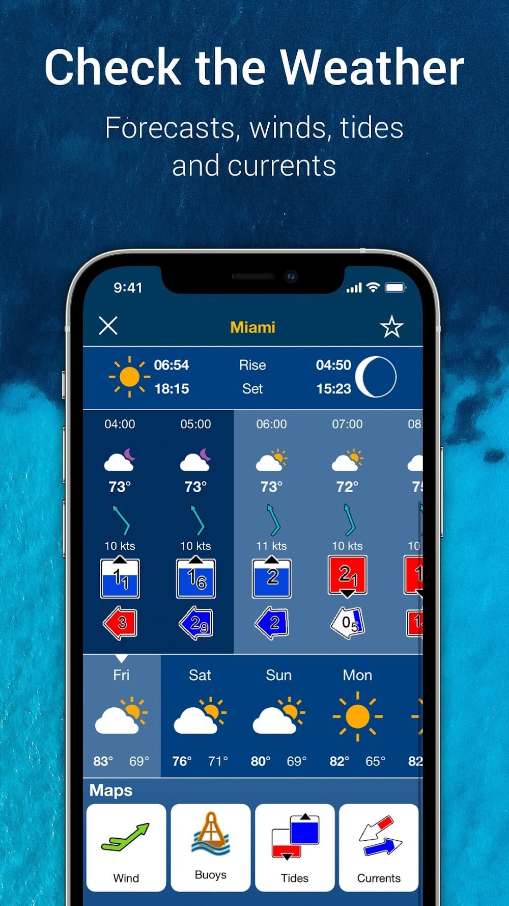
Show the specified places’ hourly and daily wind, weather buoyancy, and tide predictions on a map.
For routing and showing the distance to the destination, the required quantity of gasoline, etc., it features a
navigation component.
charts that are updated often, with over 2000 changes every day
Show several maps to illustrate the sea’s atmospheric conditions.
Show the appropriate cautions in real time.
Show user-added alerts for rocks and stones
preserving the paths you’ve traveled
Enhanced map function that draws attention to fishing and shallow areas
The ability to indicate the direction you want to go in
Wave height, temperature, and water pressure shown
assistance from many lakes and oceans
Capability to exchange GPX data with other programs
Highlights:
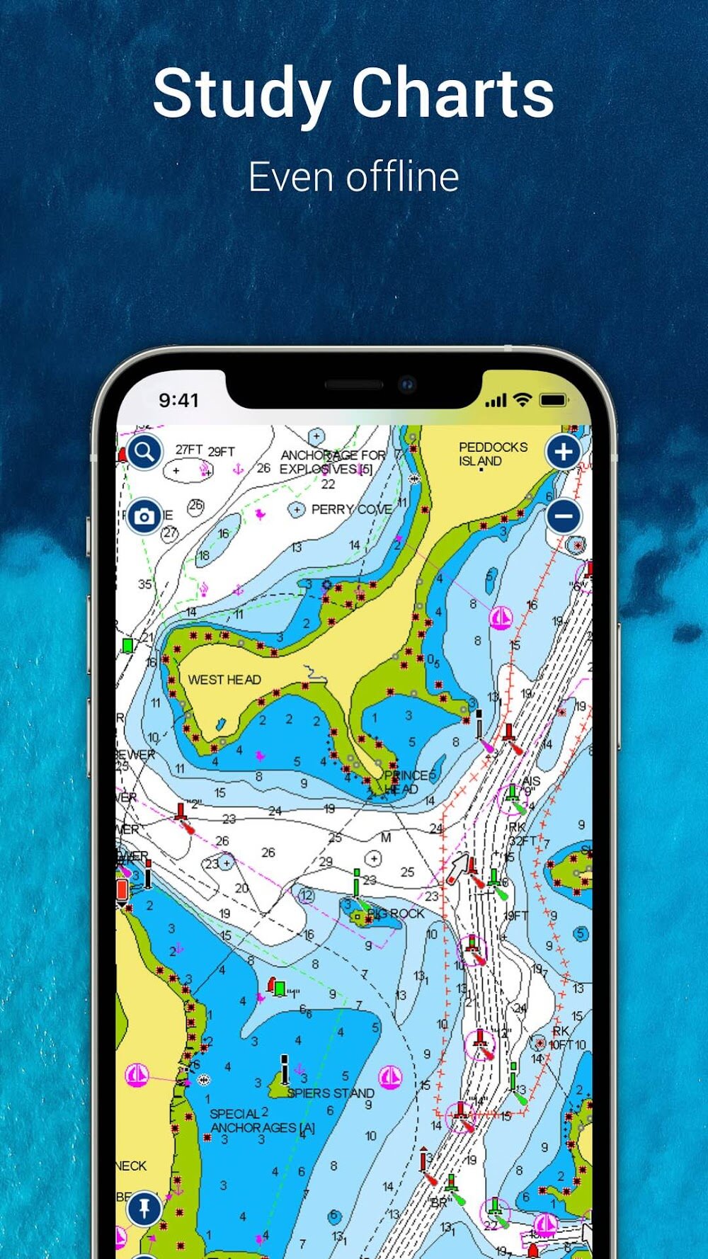
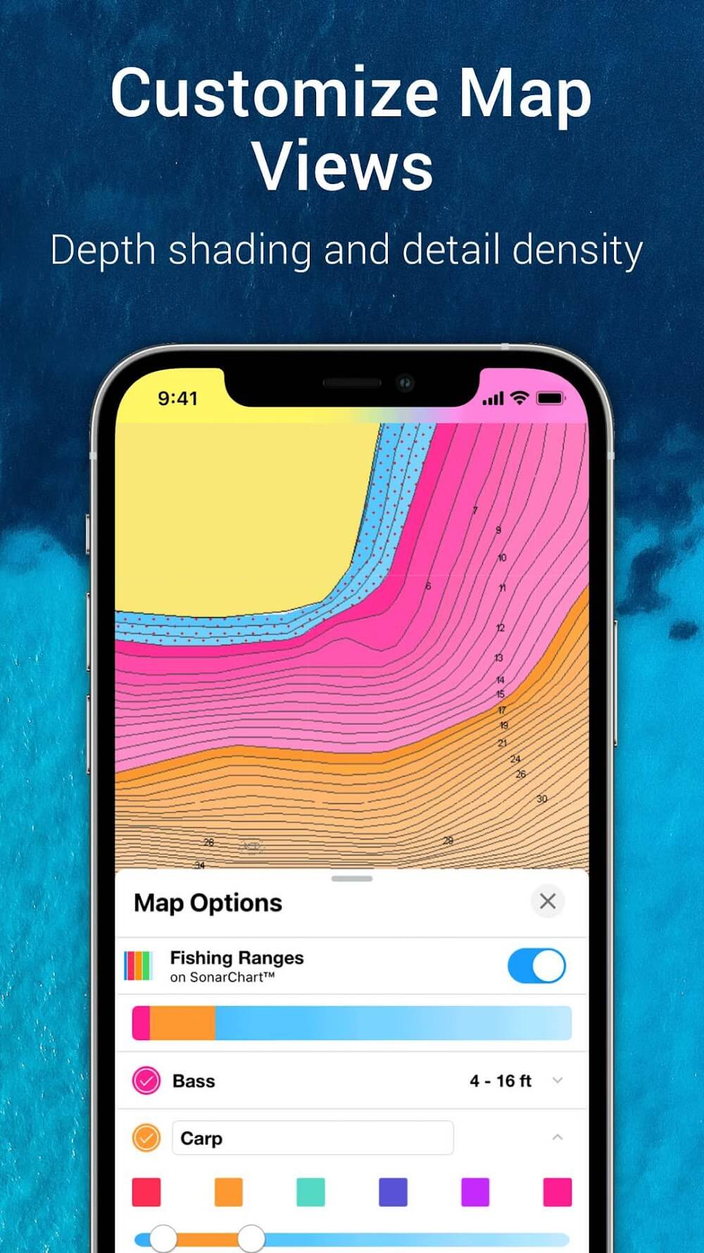
CHARTS: Use them offline along with multiple overlays, so you can be more aware of what’s above and below the water.
NAUTICAL CHART: Use this premier marine reference to study port plans, anchorages and safety depth contours, locate navaids, marine services and more.
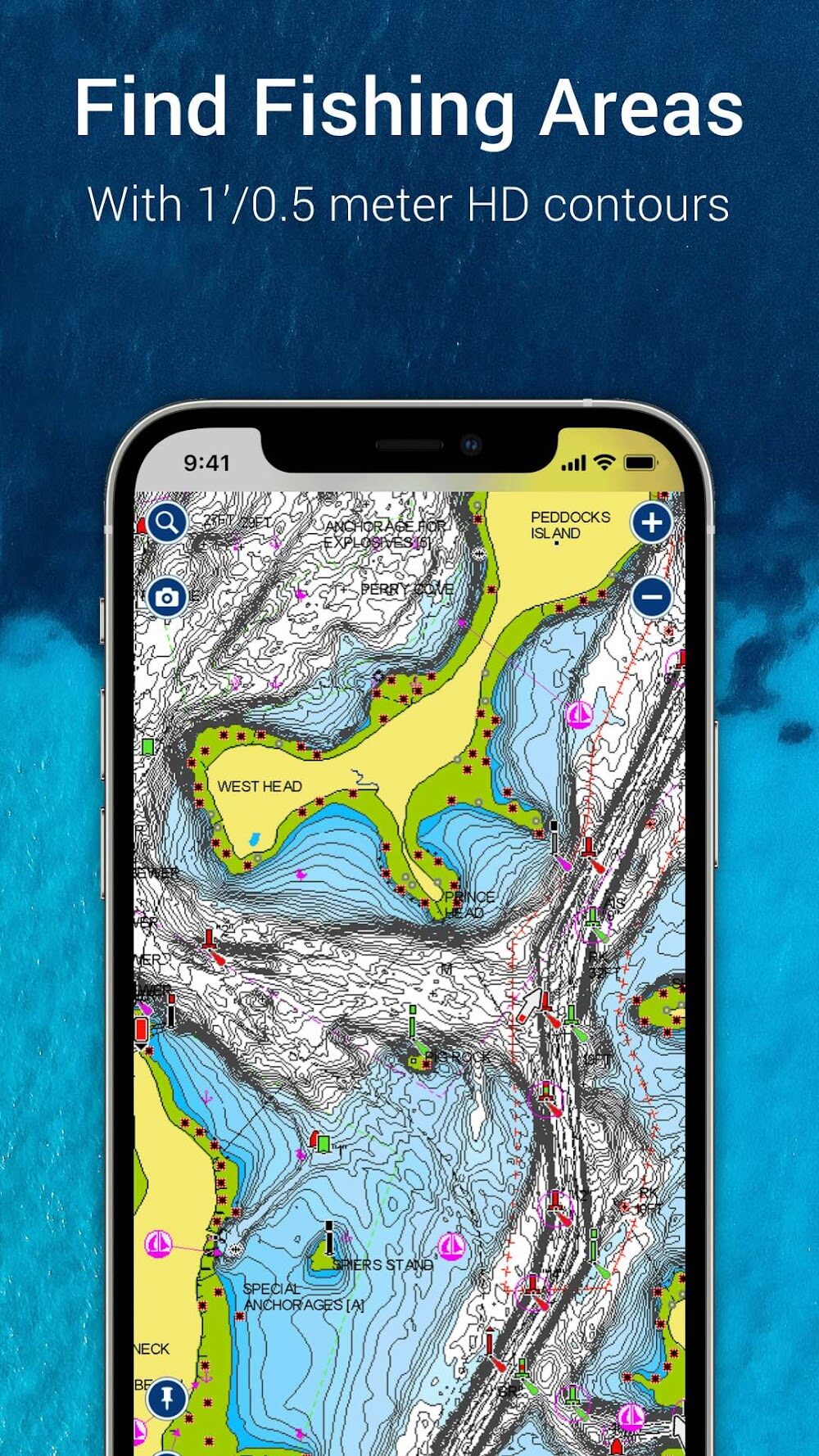
SONARCHART™ HD BATHYMETRY MAPS: Extraordinary 1’ (0.5 meter) HD bottom contour detail is the ideal tool for locating new fishing areas.
U.S. GOVERNMENT CHARTS (NOAA): These are available within the following coverages: U.S. and Canada, Mexico, Caribbean to Brazil.
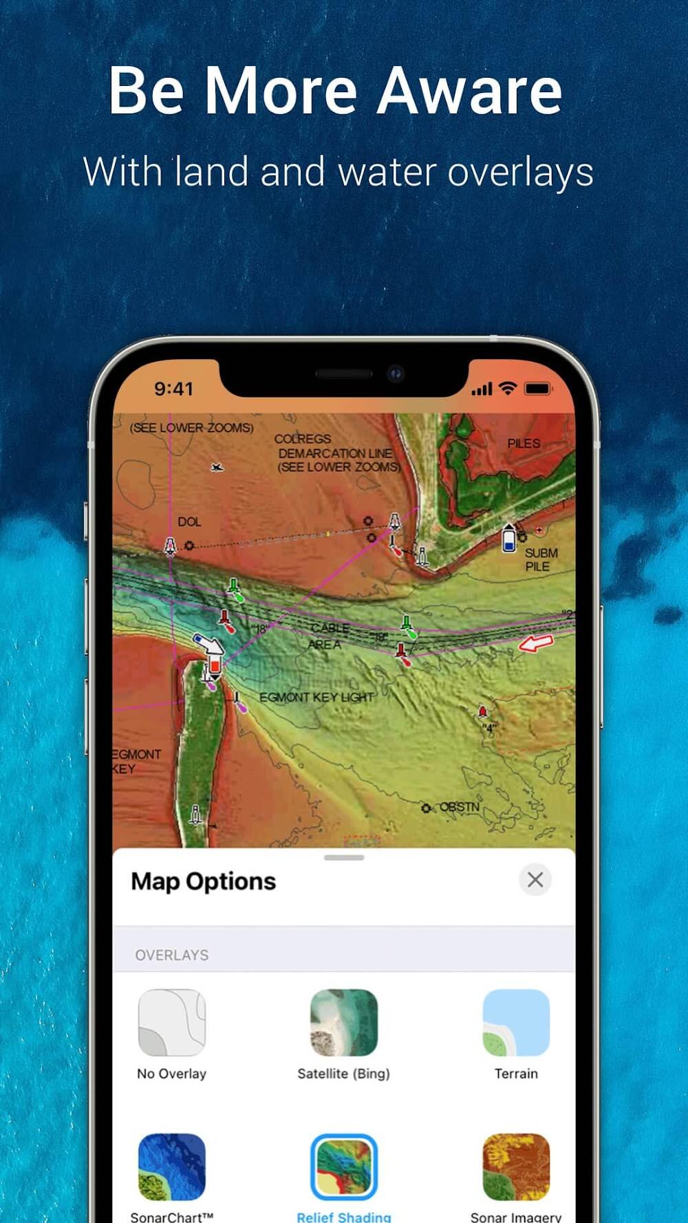
OVERLAYS: The relief shading overlay allows you to have a better understanding of bottom topography for improved fishing and diving. Sonar imagery reveals bottom hardness clearly and in vivid color on select lakes. Want more? Display satellite imagery on land and water.
MAP OPTIONS: Change chart-overlay combinations to customize chart views, activate night mode, highlight shallow areas, target multiple fishing ranges and more.
DAILY UPDATES: Benefit from up to 5,000 daily updates worldwide.
PLANNING TOOLS:
Besides presenting the most detailed and up-to-date map possible, this application also allows us to create our own plans. So during your sea exploration trip, you won’t need to worry about losing direction because there is a detailed highlight map following the locations we plan to explore. This application will always choose the most correct route for us, unlike Google Maps, one time my friend used it and instead of showing the shortest route to the destination for motorcyclists, it gave a Instructions for train vehicles.
Auto routing: This application is equipped with automatic instructions and always sets the most optimal and convenient routes for us.
Weather data: When traveling or experiencing by boat or train, the thing I always care about and worry about the most is the weather because whether your trip becomes great or not depends on it, so when using this application I feel very secure. because weather parameters are always updated in real time.
Track logging: Besides, the application also helps us save the points we have marked and record all the journeys we have made during the journey.
Distance measuring: The application also has a built-in distance calculation tool, you just need to select an origin location and any destination location on the map, it will automatically display that exact distance.
Frequently Asked Questions (FAQs):
Q: How can I download maps for offline use?
A: You can download maps for offline use by selecting the desired area and downloading them directly to your device through the app.
Q: Does the app provide real-time weather updates?
A: The app provides real-time weather updates to inform you of current conditions.
Q: Can I use the app without an internet connection?
A: You can use the app offline by downloading maps in advance.
Q: How accurate are the GPS and navigation features?
A: The GPS and navigation features are highly accurate, ensuring precise location tracking and route planning.
Q: Is the app suitable for professional maritime use?
A: The app is suitable for hobbyists and professionals, offering comprehensive tools and information for all users.
Final words:
in navionics boating mod apk, this connection helps users identify adjacent marine traffic, improving situational awareness and encouraging a safer maritime environment. Ais provides real-time information on nearby vessels' movements and positions, helping people make educated decisions and reduce the danger of crashes and navigational hazards. Wi-fi connectivity simplifies data transmission between the ais receiver and the user's device. This technology innovation improves marine operations and emphasises the need to set a predetermined and dependable range for monitoring potential collisions to maintain a secure environment. This safety precaution will give people visual and audible alerts, helping them spot and avoid collisions.
More Information
- Size:248.9MB
- Version:17.0.2
- Requirements:Android
- Votes:382
Related topics
-
When you are traveling or experiencing a new place or activity, no one wants to stare at their phone or tablet the whole time. However, you want the memories of your trips and travel to last forever, and you want to share those memories with friends and loved ones back home. The best travel logs combine both worlds with stunning features and interfaces to document your memories, photos and videos of the places that you visit and simple, easy-to-use design. These some trip logging apps let you easily capture the memories, so you can get back to enjoying it in the moment.
-
![Namma Yatri]()
Namma Yatri
-
![HERE WeGo]()
HERE WeGo
-
![GPS Emulator]()
GPS Emulator
-
![Google Maps]()
Google Maps
-
![National Train Enquiry System]()
National Train Enquiry System
-
![Porter Driver Partner App]()
Porter Driver Partner App
-
![Where is my Train]()
Where is my Train
-
![Flightradar24 Flight Tracker]()
Flightradar24 Flight Tracker
-
-
The relentless flow of time remains beyond our complete command, an ever-shifting rhythm we can never fully master. Yet within our limited sphere of influence, we may still strive to govern our own small domain - and in doing so, perhaps we achieve a kind of mastery after all. For while the vast world extends far beyond our reach, the miniature universe we hold in our hands contains infinite possibilities of its own. True control may not mean dominating the entirety of existence, but rather perfectly curating the world we can touch and shape. The cosmos stretches endlessly outward, but within our grasp lies a personal cosmos waiting to be molded.
-
![RMTS BRTS Time Table]()
RMTS BRTS Time Table
-
![Orbitz Hotels & Flights]()
Orbitz Hotels & Flights
-
![itTaxi]()
itTaxi
-
![RYDE]()
RYDE
-
![World Atlas MxGeo Pro APK]()
World Atlas MxGeo Pro APK
-
![Moovit: Transit & Bus Tracker]()
Moovit: Transit & Bus Tracker
-
![Navionics® Boating]()
Navionics® Boating
-
![PackPoint v3.17.3]()
PackPoint v3.17.3
-
-
These must-have travel apps bring global adventures to your phone, making trip planning effortless and budget-friendly. Compare flights and hotels in seconds, access offline maps and expert city guides, or master key phrases in foreign languages. Read authentic tips from locals to uncover hidden gems before you arrive. Whether you're dreaming up future journeys or navigating current travels, these tools transform wanderlust into reality. With exclusive free premium features, your digital passport to discovery is ready - download now and let your next unforgettable journey begin!
-
![Namma Yatri]()
Namma Yatri
-
![HERE WeGo]()
HERE WeGo
-
![AlMaqsad]()
AlMaqsad
-
![MAPS.ME]()
MAPS.ME
-
![National Train Enquiry System]()
National Train Enquiry System
-
![Moovit:Your Transit Tracker]()
Moovit:Your Transit Tracker
-
![Red Taxi]()
Red Taxi
-
![Avenza Maps]()
Avenza Maps
-


Latest Updated
Popular Apps


Popular News
-
![Tomie Wants to Get Married Full Walkthrough, All Choices and Ending Guide]()
Tomie Wants to Get Married Full Walkthrough, All Choices and Ending Guide
2026-05-22
-
![Karryn’s Prison Gameplay Walkthrough & Strategy Guide]()
Karryn’s Prison Gameplay Walkthrough & Strategy Guide
2025-10-28
-
![Life in Santa County Game Guide & Complete Walkthrough]()
Life in Santa County Game Guide & Complete Walkthrough
2025-10-28
-
![Dreams of Desire Complete Walkthrough and Game Guide]()
Dreams of Desire Complete Walkthrough and Game Guide
2025-10-28
-
![Era Hunter Gameplay Guide & Full Walkthrough]()
Era Hunter Gameplay Guide & Full Walkthrough
2025-10-28
More+