Offline Map Navigation v25.6.0
Download for Android This app is available for Android only.- Category:Nav
- Rating: 4.2
- Language:English
- Updated:2025-03-22
Screenshots
Introduction
The call of the wild is in all of us. It provokes exploration. It propels us to ridgelines, coastlines, high crags, deep crannies — those spaces and moments when our heart forges ahead because we can’t turn back. Because we have to know. Because we must experience it for ourselves.Whether you find yourself listening for bugles on a lonely hillside, choosing the longer trek at the fork in the trail, ripping through the desert at sunset in your SxS, or picking your ski line from the summit before the powder plunge — onX helps bring that adventure to life. Whether it’s your first step into the uncharted, or your annual backcountry trip, we unlock confidence in the unknown.onX is home to a team of passionate explorers. We celebrate our adventures, but we don’t take them for granted. Our appreciation for wild places drives us to preserve access to the recreation that we cherish. As a company, we invest in land access initiatives to expand and protect open spaces. We believe that the more people who experience their own off-the-beaten-path awakening, the more likely they are to join us in protecting these spaces for the future.onX products are built by adventurers, for adventurers. Our current suite of navigation apps includes onX Hunt, onX Offroad, and onX Backcountry. We believe that every adventurer needs to know where to go, to know where they stand, and to be able to share their experiences.
Features:
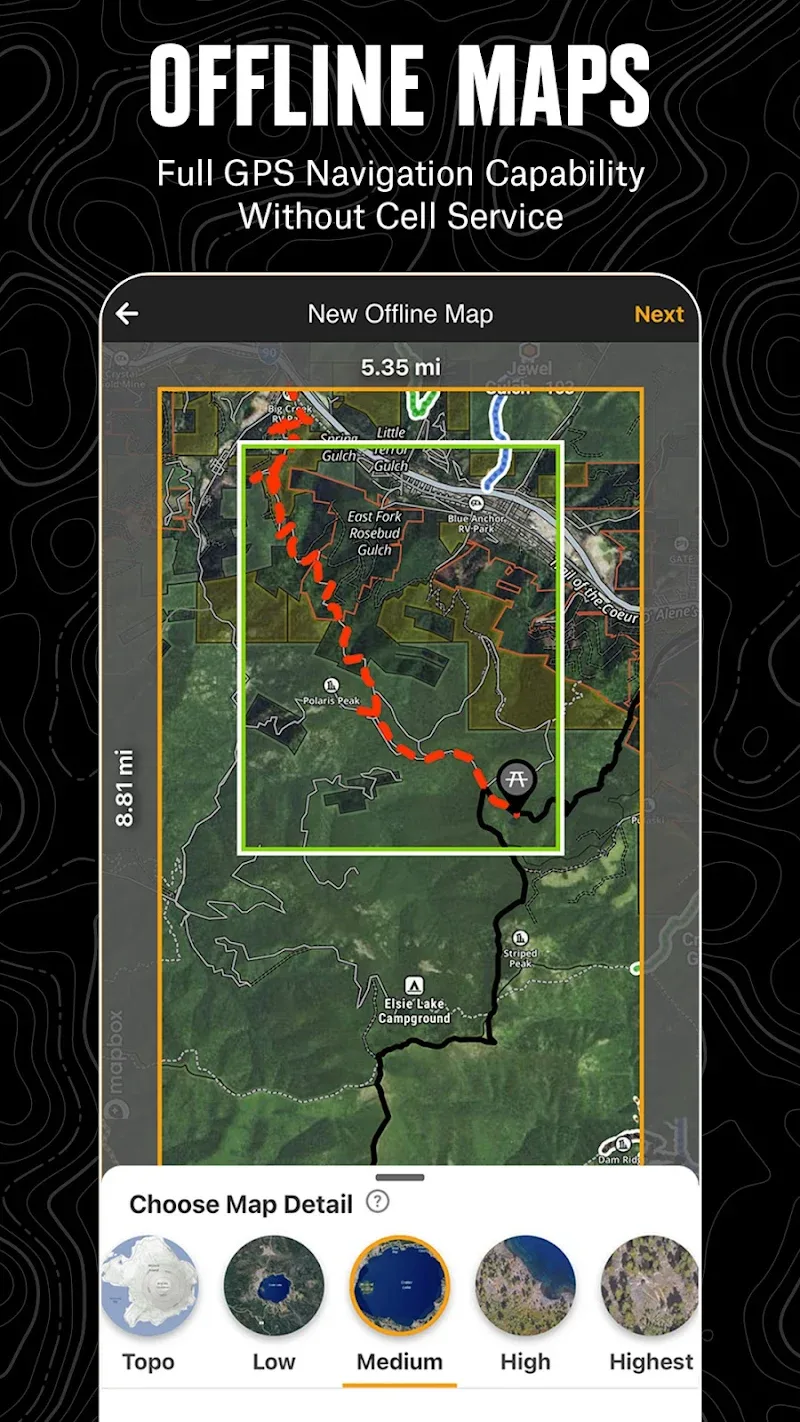
Navigate Without Cell Coverage: Save Offline Maps to bring your custom maps and adventure along when you're outside cell coverage on the trail. With the onX Offroad App, you turn your phone into a handheld GPS device using your phone's internal GPS. Navigate offline by following the blue dot to always know how to get home–wherever home is that night.
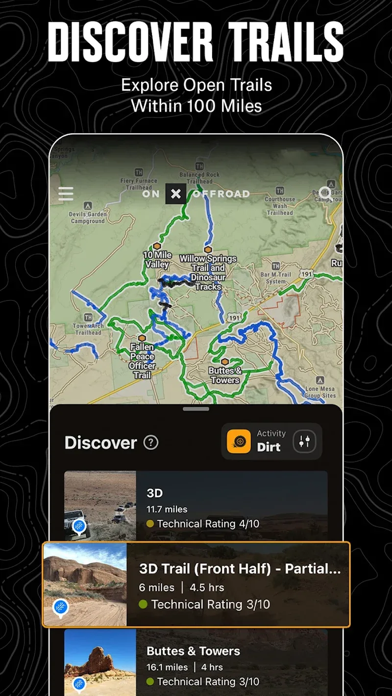
Adventure is Tap Away with Our Library of Map Data: With map data sourced from USFS, MVUM, BLM, and NPS, our color-coded basemap includes off-road trails, Public Land boundaries, and recreation points to let you quickly scan for open routes near you and locate dispersed camping or campgrounds. Tap anywhere on the map to find hiking trailheads, trailer parking, non-ethanol fuel stations, boat launches, fishing access, and more. Scout the landscape and visualize mountains by viewing your maps in 3D, topo, satellite imagery, or a hybrid.
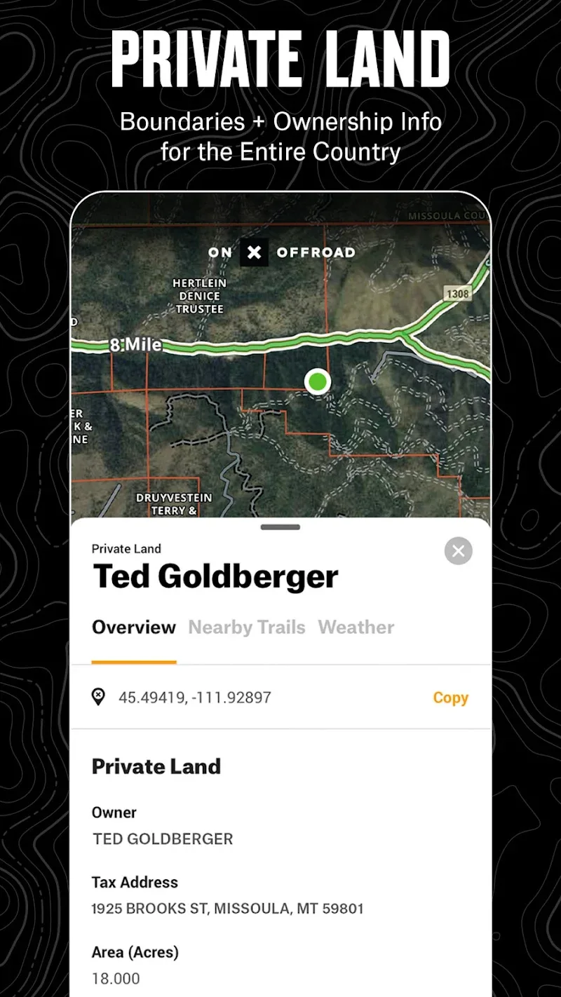
Private Property Maps With Boundaries-Elite Only: Make your maps Elite to discover more off-road access with private property boundaries and data for the whole country. Always know where you can legally off-road and camp, and find out who owns OHV trails or the property next to a trail easement with our Private Land Map Layer.
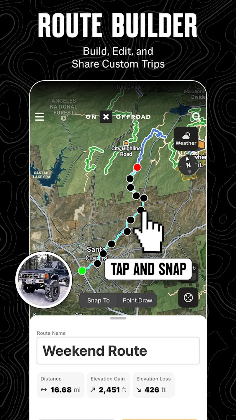
Plan, Record, Save, and Share Your Trips: Drop Waypoints to save points of interest on your maps and share locations with others. Go and Track records and saves your speed, distance, location, and leaves a breadcrumb trail so you’ll always find your way back and can share your ride with friends and family.
Off-Road Trails In Your Vehicle’s Dash: Android Auto compatibility lets you enjoy hands-free navigation and view off road trails and maps in-dash. *When in service, Android users can see their in-dash maps in 3D.
Highlights:
No Cell Coverage: Everything becomes simple when you go to a completely new location with available map features. At the same time, you can also quickly open offline maps that have been prepared before the journey begins.
Handheld GPS: All features from the system can help you locate quickly, similar to a GPS device. From there, all information becomes clearer without any difficulty in the positioning process.
Reliable Guidance: The routes are clearly displayed with different icons. In particular, you only need to focus on the blue dot, which often helps you not get lost for a long time.
Detailed Mapping: When the user has chosen a suitable location, you can often get the corresponding trails. At the same time, related locations are often displayed next to it to help you make the most of the terrain.
Multi-Source Information: These tools often create accurate information that you cannot ignore. Of course, everything often comes from quality information sources and helps you have more suitable views.
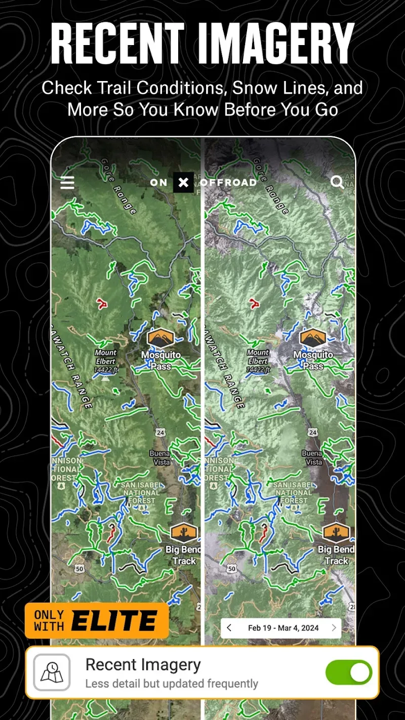
3D Visualization: The terrain not only appears in 2D but can also reflect all information through the satellite view. From there, you can freely switch between different views to study the location thoroughly.
Functions:
OHV Trails & Map Layers
Find trails for your activity – SxS, 4x4, ATV, dirt bikes, snowmobiles & more
Switch from Dirt to Snow Mode for data on groom reports & avalanche forecasts
Toggle map layers for info on weather, land boundaries & cell service
Identify cell coverage areas for AT&T, Verizon & T-Mobile
Offline Navigation & Route Builder
View open and close dates, difficulty ratings & trail photos
Save Offline Maps without losing interactive land and trail data
Get off-road turn-by-turn directions with voice commands & sync with Android Auto
Map routes that automatically snap to roads and trails
Trip Tracker & Recreation Points
Track distance, location, speed or elevation. Save & share trips with friends
GPS navigation & versatile map imagery – 3d, topo, satellite or hybrid
Add Waypoints to mark campsites, fuel stations, fishing access & more
Customize maps by marking recreation points, rock crawls or obstacles
Private Property Maps (Elite Only)
Access private land ownership information across the nation
View public land, boundaries & acreage by tapping anywhere on the map
Identify National Forest, BLM, National Park land and more
Download onX Offroad and experience a trusted planning, mapping, and navigation app that always gets you home safely.
Premium & Elite Offroad Memberships:
Enjoy our Premium features for $34.99/year. With Elite, access all of our Premium features plus property maps, land owner info, and industry brand discounts for $99.99/year.
650K+ miles of motorized roads and off-road trails
Trails for 4x4, Side-by-Side, dirtbikes, dual sport, ATV, Quads, Overlanding & snowmobiling
852M acres of public land across the U.S.
24K topographic maps and 3D maps for the entire U.S.
Designated camping areas, campsites, campgrounds, hot springs, breweries & more
Save unlimited Offline Maps for navigation without cell service
Conclusion:
onX Offroad: Trail Maps & GPS supports the process of positioning and finding routes for the convenience of many different users. The application does not need to be used too much or completely dependent on the internet so that users can easily use any area. You can also search, and the directions feature will be displayed for travel.The application provides you with many comprehensive and modern features to meet your needs. Besides, you will also be suggested the nearest and easiest route to reach the area you want in time within the allowed time. You can use the application as a special travel assistant and not be afraid of getting lost.
More Information
- Size:139MB
- Version:25.6.0
- Requirements:Android
- Votes:403
Related Versions
-
 Download
Version:25.28.0Size:112.9MB
Related topics
-
When you are traveling or experiencing a new place or activity, no one wants to stare at their phone or tablet the whole time. However, you want the memories of your trips and travel to last forever, and you want to share those memories with friends and loved ones back home. The best travel logs combine both worlds with stunning features and interfaces to document your memories, photos and videos of the places that you visit and simple, easy-to-use design. These some trip logging apps let you easily capture the memories, so you can get back to enjoying it in the moment.
-
![Namma Yatri]()
Namma Yatri
-
![HERE WeGo]()
HERE WeGo
-
![GPS Emulator]()
GPS Emulator
-
![Google Maps]()
Google Maps
-
![National Train Enquiry System]()
National Train Enquiry System
-
![Porter Driver Partner App]()
Porter Driver Partner App
-
![Where is my Train]()
Where is my Train
-
![Flightradar24 Flight Tracker]()
Flightradar24 Flight Tracker
-
-
The relentless flow of time remains beyond our complete command, an ever-shifting rhythm we can never fully master. Yet within our limited sphere of influence, we may still strive to govern our own small domain - and in doing so, perhaps we achieve a kind of mastery after all. For while the vast world extends far beyond our reach, the miniature universe we hold in our hands contains infinite possibilities of its own. True control may not mean dominating the entirety of existence, but rather perfectly curating the world we can touch and shape. The cosmos stretches endlessly outward, but within our grasp lies a personal cosmos waiting to be molded.
-
![RMTS BRTS Time Table]()
RMTS BRTS Time Table
-
![Orbitz Hotels & Flights]()
Orbitz Hotels & Flights
-
![itTaxi]()
itTaxi
-
![RYDE]()
RYDE
-
![World Atlas MxGeo Pro APK]()
World Atlas MxGeo Pro APK
-
![Moovit: Transit & Bus Tracker]()
Moovit: Transit & Bus Tracker
-
![Navionics® Boating]()
Navionics® Boating
-
![PackPoint v3.17.3]()
PackPoint v3.17.3
-
-
These must-have travel apps bring global adventures to your phone, making trip planning effortless and budget-friendly. Compare flights and hotels in seconds, access offline maps and expert city guides, or master key phrases in foreign languages. Read authentic tips from locals to uncover hidden gems before you arrive. Whether you're dreaming up future journeys or navigating current travels, these tools transform wanderlust into reality. With exclusive free premium features, your digital passport to discovery is ready - download now and let your next unforgettable journey begin!
-
![Namma Yatri]()
Namma Yatri
-
![HERE WeGo]()
HERE WeGo
-
![AlMaqsad]()
AlMaqsad
-
![MAPS.ME]()
MAPS.ME
-
![National Train Enquiry System]()
National Train Enquiry System
-
![Moovit:Your Transit Tracker]()
Moovit:Your Transit Tracker
-
![Red Taxi]()
Red Taxi
-
![Avenza Maps]()
Avenza Maps
-


Latest Updated
Popular Apps


Popular News
-
![Tomie Wants to Get Married Full Walkthrough, All Choices and Ending Guide]()
Tomie Wants to Get Married Full Walkthrough, All Choices and Ending Guide
2026-05-22
-
![Karryn’s Prison Gameplay Walkthrough & Strategy Guide]()
Karryn’s Prison Gameplay Walkthrough & Strategy Guide
2025-10-28
-
![Life in Santa County Game Guide & Complete Walkthrough]()
Life in Santa County Game Guide & Complete Walkthrough
2025-10-28
-
![Dreams of Desire Complete Walkthrough and Game Guide]()
Dreams of Desire Complete Walkthrough and Game Guide
2025-10-28
-
![Era Hunter Gameplay Guide & Full Walkthrough]()
Era Hunter Gameplay Guide & Full Walkthrough
2025-10-28
More+